

Priority 1 and 2 Areas in the Watershed Protection Overlay District - WHY IT MATTERS
The areas shown indicate Priority 1 and 2 Zones in the Haggetts pond area. The Haggetts Pond trail runs through mostly Priority 1 areas with the northern portion connecting to High Plain Rd. a Priority 2 Zone.
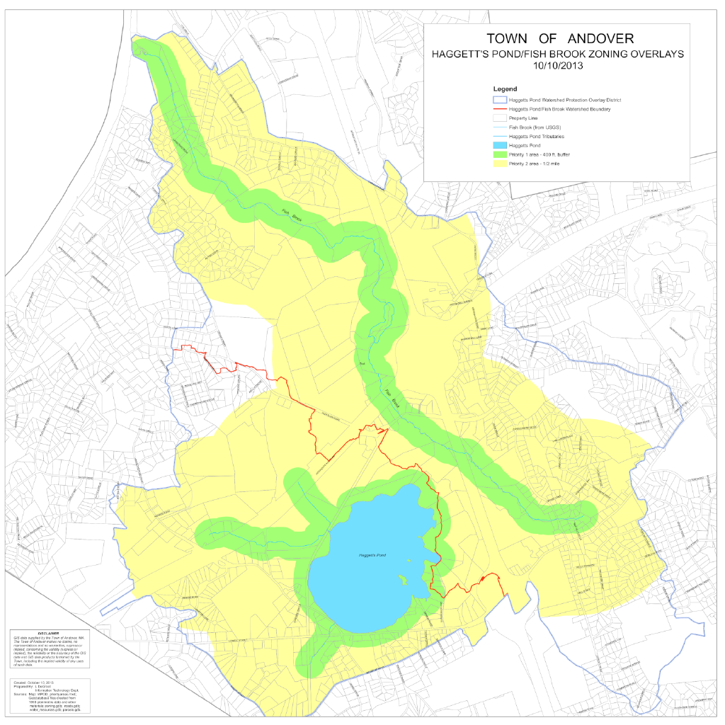
Within the meaning of current Andover bylaws that protect our drinking water supply, these areas have the following definitions and restrictions that the BSC design and Facility Department projects are ignoring:
Priority 1 : (green areas in the map) land areas up to 400 feet from the annual high water levels of Haggett’s Pond, its tributaries, and Fish Brook, respectively.
Priority 2: (yellow areas in the map) land areas exceeding 400 feet and extending out to 1/2 mile from the edge of Priority Zone 1. Priority Zones 1 and 2 shall apply to Fish Brook and any other Class A water source that is tributary to surface water supplies within the WPOD to a distance of 200 feet from the source.
There are numerous restrictions according the Andover Zoning Bylaws 8.8.6. The ones most pertinent to the proposed BSC design of the new asphalt paved multi-use trail include:
5. Any new building, structure, land-disturbing activities, excavation, or fill within 50 feet of all water bodies and watercourses as defined in this Bylaw; except for that which is necessary for the operation, modification, repair, replacement, or expansion of the Town’s public drinking water supply system, and foot, bicycle, and/or horse paths and bridges and other systems that will be consistent with the purposes set forth in Section 8.8.1;
18. Earth removal, consisting of the removal of soil, loam, sand, gravel, or any other earth material (including mining activities) to within four feet of historical high groundwater as determined from monitoring wells and historical water table fluctuation data compiled by the United States Geological Survey, except for excavations for building foundations, roads, or utility works;
20. Prohibitions not otherwise specified herein, but provided for in 310 CMR 22.20B, Surface Water Supply Protection.
Item 20 in Section 8.8.1 refers to Commonwealth’s regulations ( CMR 310 22 ), which include the following restrictions relevant to this project:
CMR 310 22(B)(2)(l) land uses that result in the rendering impervious of more than 15%, or more than 20% with artificial recharge, or 2500 square feet of any lot, whichever is greater;