Skip to content Skip to footer

Water Quality

ADA Access Does Not Require Risking Water Safety

Risks to Water Quality Contained in the BSC Design Promoted by Andover Town Officials

The BSC Design introduced the following risks to our water supply:

  1. Asphalt Paving
  2. Excavation of a Rail Bed

Asphalt Paving Risks to Water Quality

Asphalt paving poses several potential indirect risks associated with asphalt.  One factor is the asphalt itself and the other is the proximity.  The current rail trail runs adjacent to Haggetts Pond and through wetlands which means that even a small amount of runoff will have substantial impact as it will not have infiltrated through layers of soil and and subsoil over a longer period of time.

Runoff Contamination: During rainfall or when water comes into contact with asphalt surfaces, there is the potential for runoff to pick up contaminants such as oils, heavy metals, and debris from the pavement. If this runoff is not properly managed, it can enter stormwater systems and eventually reach water bodies, potentially impacting water quality.

Chemical Additives: Some asphalt mixtures may contain additives or binders that could leach into the surrounding environment under certain conditions.  The BSC Design calls for porous asphalt without providing further details of its chemical composition, whether it has been recycled (typically a source of heavy metals and other toxic contaminants).  

Maintenance Activities: The use of sealants, coatings, or other maintenance activities on asphalt surfaces may introduce chemicals into the environment.  The town claims that it does not plan to distribute rock salt on the trail, but this remains to be seen given the expected increase in bicycle and other traffic that could lead to injuries from slippery surfaces during cold months (and claims against the town)  

Cracking and Deterioration: As asphalt surfaces age, they may develop cracks or deteriorate, leading to the release of materials into the environment. If not properly managed, these materials may find their way into water sources.  Additionally, because porous asphalt (which is part of the BSC proposal) can erode more quickly than sealed asphalt, one can assume it will erode and require replacement more often.

The designs proposed by BSC Design and promoted by the town’s employees involve excavating a 1.6 mile strip of land about 10′ wide that runs through protected areas surrounded out town’s drinking water supply.  The BSC Design further involves layering filler and then asphalt on top.  Additional features of the design involve leveling dozens of square feet of wetland near the southwest entrance at Haggett’s Pond to place a new 24 space parking lot.  

As discussed on the Governance page, projects such as this conducted within 200 feet of not only wetlands but a reservoir – our drinking water supply – are subject to a formal review.  At least, that is what our town’s bylaws set forth (See Town of Andover Wetland Protection Regulations).

Railbed Excavation Risks to Water Quality

Although the existing railbed provides a firm, hard pack surface suitable for many wheelchairs in most parts of the trail, the BSC Design involves excavation of this surface in order to make space for new fill and asphalt paving.  

The excavation of old rail beds carry a number of risks:

Soil Contamination: Old rail beds may have been treated with
various chemicals, including herbicides, pesticides, and preservatives, which could have leached into the soil over time. Excavating these areas without proper precautions could release contaminants into the water, affecting its quality.

Sediment Disruption: The excavation process can disturb sediment in the area, potentially releasing suspended particles into the water. This can lead to increased turbidity, which may affect water quality and impact aquatic life.

Erosion and Runoff: Excavation activities may expose bare soil, leading to increased erosion risks. If proper erosion control measures are not in place, sediment-laden runoff could enter the water source, carrying pollutants and compromising water quality.

Disturbance of Aquatic Ecosystems: Excavation can disrupt the habitats of aquatic organisms, including fish and other aquatic species.  This disturbance may lead to changes in the ecosystem dynamics and impact the overall health of the water body.

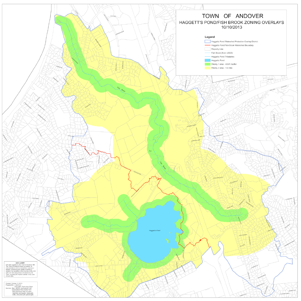
The BSC Design Group and the Town of Andover have ignored these risks in our judgment.  A thorough site assessment that includes soil tests of the rail bed would indicate any potential hazards.  While the town has conducted soil tests, these were done in the general vicinity and not in the rail bed itself.  The type of soil tests needed to definitively determine if the project could proceed safely have not been done.

Also concerning are planned (or lack of) erosion control measures.  The current trail runs over some ancient culverts that allow water to pass between the pond and neighboring wetlands.  Some of these culverts are decrepit and in need of repair.  The latest BSC Design states that the culverts will not be touched.  It is wishful thinking that these culverts may not collapse under the weight of heavy equipment or as the hard pack layer above them is disturbed. 

Massachusetts state level Energy and Environmental Affairs Department observed these risks in its initial response to the town’s Notice of Intent (Read the EEAD Response Here).

The lack of a formal review by the Planning Department, discussed in the column on the right, is a cause of additional concern.  A project this extensive ought undergo expert oversight and a formal review process.  The trail will be enjoyed by a limited portion of the town in any form; our drinking water supply is a critical need for every resident.  Instead, the Town, most notably the Facilities Department and the Commission on Disability are seeking to expedite the project at every turn. 

Water Quality Regulation and Administration in Andover

As discussed in the Conservation page, the area through which the rail trail currently runs adjacent to Haggetts Pond is a Priority 1 area for protected species.  It is also within the towns “Watershed Protection Overlay District” (WPOD) that covers Haggetts Pond, the area of the rail trail, as well as abutting residential and commercial properties.  The effect of the WPOD is to create a special zone where any construction or improvement must be approved by the town’s Planning Board.  The reason for this special zone is to protect the town’s water supply. 

Haggetts Pond Priority 1 and 2 Zoning Overlays


Historically, both the Conservation Commission and the Planning Board have been very strict in enforcing the bylaws with regard to adjacent lands.  In past years, a resident was denied permission to repair a sports court; another resident was required to dismantle a stone wall that he had built.  The town’s Commissions have established a precedent of no tolerance for the remotest disturbance to the watershed for the purpose of conservation and water quality protection.

The BSC design represents risk and impact that is several orders of magnitude greater than any of these small projects.  As of the writing, the Conservation Commission continues to deliberate and is waiting for a report from “peer reviewers” on the BSC.

However, the Planning Board has not even scheduled a review of the project, even though this is subject to their purview because it is located within the WPOD and has substantial impact due to the materials (asphalt), size (1.6 miles and 10′ wide once excavated) and proximity to the pond (within a few feet for a considerable portion).  These activities are explicitly defined as prohibited activities in our town’s own bylaws designed to ensure water safety

Friends of Haggetts Pond asked this question at the January, 2024 Select Board meeting, but it was not answered.  Numerous members have reached out by email as well.  We are still waiting for a comprehensive response from a member of the Planning Board itself.  

Needless to say, we find the disconnect between the current posture and the watershed protections bylaws (as well as past precedent set by both the Conservation Commission and Planning Board) concerning as a matter of water protection and lawful governance.

This disconnect and the lack of response contributed to the decision by Friends of Haggetts Pond to petition the town for a Special Town Meeting

Learn MOre

Explore topics related to the issue below.

Priority 1 and 2 Zones

Priority 1 and 2 Areas in the Watershed Protection Overlay District - WHY IT MATTERS The areas shown indicate Priority 1 and 2 Zones in the Haggetts pond area.  The Haggetts Pond trail…

Read more

Paving Paradise: The Perils of Impervious Surfaces

Source Author: Lance Frazer Publication: Environmental Health Perspectives · Volume 113, Issue 7 · Pages A456 - A462 https://doi.org/10.1289/ehp.113-a456 Full Article Excerpts Runoff Effect on Nearby Habitats and Water Sources "On a road…

Read more

Eminent Domain Taking of B&M Railroad Parcel Next to Haggetts Pond in 1932

Original B&M Eminent Domain Taking

Text of the original taking of the B&M parcel containing the rail trail The original "taking" voted by the Select Board in 1932 specified that the purpose was to protect the water supply. …

Read more

Alternative ADA Path Designs and Locations

Key Points Andover's Shawsheen River Masterplan makes several important points with regard to the current Haggetts Pond asphalt paved multi-use plan: The Shawsheen River bank and Pomps Pond offer opportunities to build ADA…

Read more